Canals are very interesting for Cal/Val activities of satellite altimetry as they represent a simple case for evaluating the performances of altimetry over inland waters. Indeed, canals have the following valuable characteristics:
- The canals have a controlled water level which results in a low temporal evolutionCanals are very calm which allow to avoid any surface roughness issues. The resulting radar echoes are very specular which is a simple case for satellite altimetry
- No topography effect. It is thus easy to monitor with only one in-situ station.
- Canals are easy sites to equip with in-situ stations and are most of the time well monitored with existing in-situ sensors.
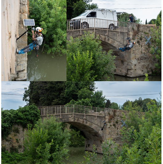
During the St3TART project, a specific campaign was performed over the Canal du Midi, near the town of Trèbes (France). This site was chosen because the “Canal du Midi” is a little canal with a controlled water surface height, an ideal geometry (the canal is perpendicular to the Sentinel-3 track), and is therefore an ideal case to evaluate the best possible performances that can be achieved by Sentinel-3. The station is installed on a bridge crossing the “Canal du Midi”, just below a Sentinel-3 track.
Once the computation of the reference height of the Micro-Station done, the station provides the precise height of the water level measured by the LiDAR.
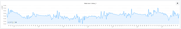
The water surface height on “trèbes_1” is very stable, as expected.
These measurements can be used to compute a FRM (Fiducial Reference Measurement) and then compare it to Sentinel-3 data.
As the in-situ sensor is installed just under the satellite ground track, the computation of the FRM is very simple: there is no slope to be accounted for, no other in-situ data is required, and the measurement of the in-situ sensor can be performed at the exact same time as the satellite passes. The FRM simply corresponds to the measurement of the vorteX.io Micro-Station that has been configured to perform a measurement at the exact time of the Sentinel-3 pass.
The steps for the comparison are the following ones:
- Extraction of the water target of interest in the Topage database (French river mask database)
- Selection of the nearest data to the target centreline (coloured points) for each transect
- Computation of WSH for S3 and selection of in-situ measurement at the same time
- Computation of Root Mean Square Error (RMSE) between the two timeseries
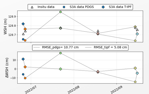
The results obtained on the comparison between the FRM on the Trèbes site and Sentinel-3A data is about 10 cm of RMSE for L2 PDGS products and 5.08 cm of RMSE with the new Sentinel-3 Thematic hydro products, which depicts the excellent performance of Sentinel-3A on this site, in accordance with the Mission Requirements.